
Rutas y Senderismo Cantabria
Rutas
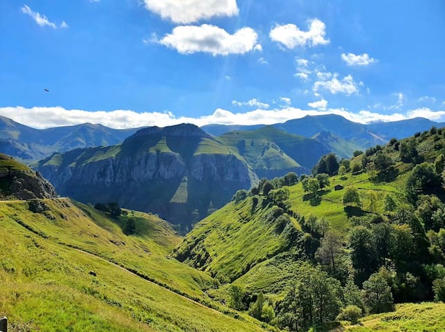
Ruta de dificultad fácil/media. Tan sólo tiene un tramo al principio de 30 minutos de subida, después todo llano.
Tiene unos 12km de longitud en total, discurre por el cañón que forma el río Cares, en los Picos de Europa.
Se tardan unas 4 horas en llegar al pueblo y después hay que realizar el recorrido de vuelta.
Easy/medium difficulty route. It only has one section at the beginning of 30 minutes of ascent, then all flat.
It is about 12km long in total, it runs through the canyon that forms the Cares River, in the Picos de Europa.
It takes about 4 hours to get to the town and then you have to make the return journey.
8 當地人推薦
The Cares Trail
Ruta del CaresRuta de dificultad fácil/media. Tan sólo tiene un tramo al principio de 30 minutos de subida, después todo llano.
Tiene unos 12km de longitud en total, discurre por el cañón que forma el río Cares, en los Picos de Europa.
Se tardan unas 4 horas en llegar al pueblo y después hay que realizar el recorrido de vuelta.
Easy/medium difficulty route. It only has one section at the beginning of 30 minutes of ascent, then all flat.
It is about 12km long in total, it runs through the canyon that forms the Cares River, in the Picos de Europa.
It takes about 4 hours to get to the town and then you have to make the return journey.
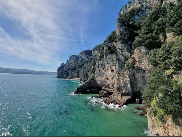
Senda fácil a lo largo de la costa con bonitas vistas. Puede empezarse en el pueblo de Santoña y transcurre por el Faro del Caballo y el Faro del Pescador.
Easy path along the coast with beautiful views. It can be started in the town of Santoña and runs through the Horse Lighthouse and the Fisherman's Lighthouse.
11 當地人推薦
Monte Buciero
Senda fácil a lo largo de la costa con bonitas vistas. Puede empezarse en el pueblo de Santoña y transcurre por el Faro del Caballo y el Faro del Pescador.
Easy path along the coast with beautiful views. It can be started in the town of Santoña and runs through the Horse Lighthouse and the Fisherman's Lighthouse.
Barrio Ruiseñada 122, Ruiseñada, Cantabria
El monte Corona es un espacio protegido cerca de Cabezón de la Sal con varias rutas de montaña.
Mount Corona is a protected area near Cabezón de la Sal with several mountain routes.
8 當地人推薦
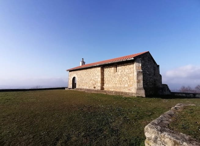
Ermita San Esteban, Monte Corona
122C Barrio RuiseñadaBarrio Ruiseñada 122, Ruiseñada, Cantabria
El monte Corona es un espacio protegido cerca de Cabezón de la Sal con varias rutas de montaña.
Mount Corona is a protected area near Cabezón de la Sal with several mountain routes.
Calle Fuente la riega 0, Camaleño, Cantabria.
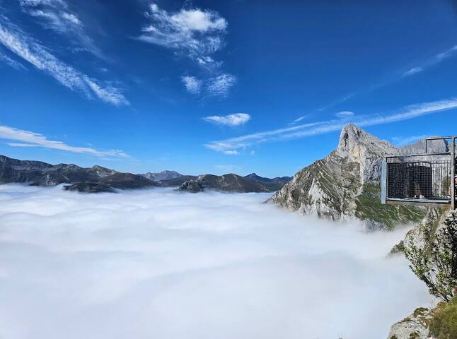
Utilizando el teleférico de Fuente Dé se puede subir al Puerto de Aliva, desde el cual realizar varias rutas todas con vuelta al teleférico. Se puede comprar entradas en su página web.
Using the Fuente Dé cable car you can go up to the Port of Aliva, from which you can make several routes all back to the cable car. You can buy tickets on their website.
41 當地人推薦
Teleferico Fuente Dé
0 C. Fuente la RiegaCalle Fuente la riega 0, Camaleño, Cantabria.
Utilizando el teleférico de Fuente Dé se puede subir al Puerto de Aliva, desde el cual realizar varias rutas todas con vuelta al teleférico. Se puede comprar entradas en su página web.
Using the Fuente Dé cable car you can go up to the Port of Aliva, from which you can make several routes all back to the cable car. You can buy tickets on their website.
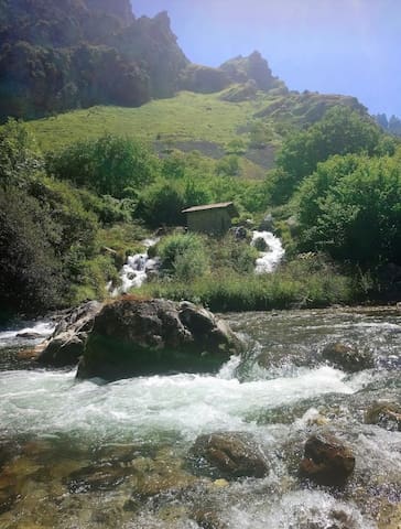
La ruta de las 28 cascadas discurre por las veredas de los ríos Yera y Ajan, durante 18km de ruta de dificultad moderada por los montes de Cantabria.
The route of the 28 waterfalls runs along the paths of the Yera and Ajan rivers, for 18km of route of moderate difficulty through the mountains of Cantabria.
Río Yera, 39685, Cantabria, 西班牙
La ruta de las 28 cascadas discurre por las veredas de los ríos Yera y Ajan, durante 18km de ruta de dificultad moderada por los montes de Cantabria.
The route of the 28 waterfalls runs along the paths of the Yera and Ajan rivers, for 18km of route of moderate difficulty through the mountains of Cantabria.
Cerca del Desfiladero de La Hermida.
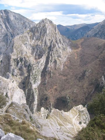
Complicada ruta desde el Canal del Rio Urdón hasta el pueblo de Tresviso. Son unas cuatro horas de subida intensa entre preciosas montañas. Conviene empezar por la mañana para comer en el pueblo.
Complicated route from the Canal del Rio Urdón to the town of Tresviso. It's about four hours of intense ascent between beautiful mountains. It is advisable to start in the morning to eat in the village.
RutasTresviso
Cerca del Desfiladero de La Hermida.
Complicada ruta desde el Canal del Rio Urdón hasta el pueblo de Tresviso. Son unas cuatro horas de subida intensa entre preciosas montañas. Conviene empezar por la mañana para comer en el pueblo.
Complicated route from the Canal del Rio Urdón to the town of Tresviso. It's about four hours of intense ascent between beautiful mountains. It is advisable to start in the morning to eat in the village.
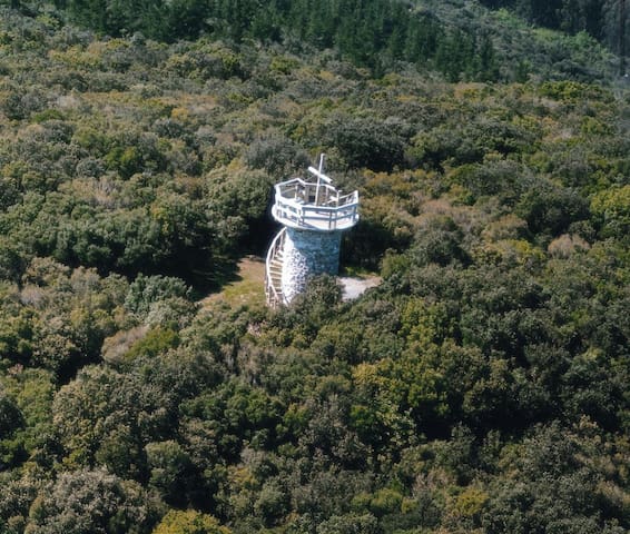
Ruta de unos 90 minutos, de dificultad media, por un bosque hasta llegar al mirador del Monte Cincho, una antigua construcción celta.
Monte Cincho
Ruta de unos 90 minutos, de dificultad media, por un bosque hasta llegar al mirador del Monte Cincho, una antigua construcción celta.