
Isabel's Guidebook
Tour and Transportation Company
Is the best tour company in Puerto Rico 🇵🇷 787-690-8040. When you call let them know is from unit 8203 for discount
Bespoke Lifestyle Management
5900 Avenida Isla VerdeIs the best tour company in Puerto Rico 🇵🇷 787-690-8040. When you call let them know is from unit 8203 for discount
Lugares emblemáticos
Old San Juan is home to the San Juan National Historic Site, with buildings dating from the 16th century, including the San Felipe del Morro and San Cristóbal fortresses and the old city walls. The Bautista Cathedral houses the tomb of Spanish explorer Juan Ponce de León. Brightly colored houses line cobbled streets and shady plazas, alongside cool cocktail bars and renowned Caribbean fusion restaurants. ― Google
902 當地人推薦
Viejo San Juan
Old San Juan is home to the San Juan National Historic Site, with buildings dating from the 16th century, including the San Felipe del Morro and San Cristóbal fortresses and the old city walls. The Bautista Cathedral houses the tomb of Spanish explorer Juan Ponce de León. Brightly colored houses line cobbled streets and shady plazas, alongside cool cocktail bars and renowned Caribbean fusion restaurants. ― Google
Castillo San Felipe del Morro, also known as El Morro, is a citadel built between 16th and 18th centuries in San Juan, Puerto Rico. Wikipedia
492 當地人推薦
El Morro
Calle BeneficenciaCastillo San Felipe del Morro, also known as El Morro, is a citadel built between 16th and 18th centuries in San Juan, Puerto Rico. Wikipedia
Cueva Ventana is a large cave situated atop a limestone cliff in Arecibo, Puerto Rico, overlooking the Río Grande de Arecibo valley. It is visible from the PR-123 but is accessible from a trail that begins adjacent to a Puma gas station located along PR-10 on kilometer 75. Wikipedia
224 當地人推薦
窗口洞穴
Cueva Ventana is a large cave situated atop a limestone cliff in Arecibo, Puerto Rico, overlooking the Río Grande de Arecibo valley. It is visible from the PR-123 but is accessible from a trail that begins adjacent to a Puma gas station located along PR-10 on kilometer 75. Wikipedia
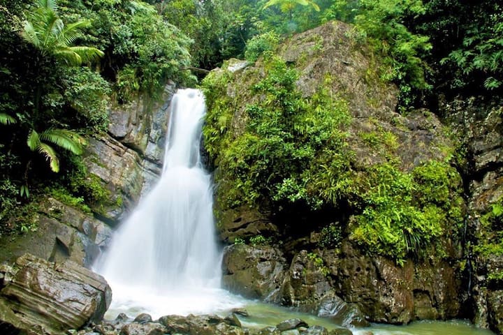
El Yunque National Forest, formerly known as the Caribbean National Forest, is a forest located in northeastern Puerto Rico. It is the only tropical rainforest in the United States National Forest System and the United States Forest Service. This forest is commonly known as El Yunque, which may be attributed to either a Spanish approximation of the aboriginal Taíno word yu-ke which means "white lands", or the word "anvil," which is yunque in Spanish. The second-tallest mountain within El Yunque is also named El Yunque. El Yunque National Rainforest is located on the slopes of the Sierra de Luquillo mountains, encompassing 28,000 acres of land, making it the largest block of public land in Puerto Rico. The highest mountain peak in the forest rises 3,494 feet above sea level. Ample rainfall creates a jungle-like setting—lush foliage, crags, waterfalls, and rivers are a prevalent sight. The forest has a number of trails from which the jungle-like territory's flora and fauna can be appreciated. El Yunque is also renowned for its unique Taíno petroglyphs. Wikipedia
1253 當地人推薦
El Yunque Rain Forest
El Yunque National Forest, formerly known as the Caribbean National Forest, is a forest located in northeastern Puerto Rico. It is the only tropical rainforest in the United States National Forest System and the United States Forest Service. This forest is commonly known as El Yunque, which may be attributed to either a Spanish approximation of the aboriginal Taíno word yu-ke which means "white lands", or the word "anvil," which is yunque in Spanish. The second-tallest mountain within El Yunque is also named El Yunque. El Yunque National Rainforest is located on the slopes of the Sierra de Luquillo mountains, encompassing 28,000 acres of land, making it the largest block of public land in Puerto Rico. The highest mountain peak in the forest rises 3,494 feet above sea level. Ample rainfall creates a jungle-like setting—lush foliage, crags, waterfalls, and rivers are a prevalent sight. The forest has a number of trails from which the jungle-like territory's flora and fauna can be appreciated. El Yunque is also renowned for its unique Taíno petroglyphs. Wikipedia
La Fortaleza is the official residence of the Governor of Puerto Rico. It was built between 1533 and 1540 to defend the harbor of San Juan. The structure is also known as Palacio de Santa Catalina translative Is the oldest executive mansion in continuous use in the New World. It was listed by UNESCO in 1983 as part of the World Heritage Site "La Fortaleza and San Juan National Historic Site". During the 1640 reconstruction, the chapel of Santa Catalina, which originally existed outside the walls, was demolished and was integrated to the walls of the structure, resulting in the alternate name Santa Catalina's Castle. Wikipedia
85 當地人推薦
La Fortaleza
63 C. de la FortalezaLa Fortaleza is the official residence of the Governor of Puerto Rico. It was built between 1533 and 1540 to defend the harbor of San Juan. The structure is also known as Palacio de Santa Catalina translative Is the oldest executive mansion in continuous use in the New World. It was listed by UNESCO in 1983 as part of the World Heritage Site "La Fortaleza and San Juan National Historic Site". During the 1640 reconstruction, the chapel of Santa Catalina, which originally existed outside the walls, was demolished and was integrated to the walls of the structure, resulting in the alternate name Santa Catalina's Castle. Wikipedia
Cueva del Indio, in Las Piedras, Puerto Rico, is a prehistoric rock art site in what is now a public park. It was listed on the National Register of Historic Places in 2003. Artifacts at the site appear to stem from Late Ceramic Period, third phase, i.e. from A.D. 1200 to 1500. Wikipedia
6 當地人推薦
Cueva del Indio Natural Reserve
Cueva del Indio, in Las Piedras, Puerto Rico, is a prehistoric rock art site in what is now a public park. It was listed on the National Register of Historic Places in 2003. Artifacts at the site appear to stem from Late Ceramic Period, third phase, i.e. from A.D. 1200 to 1500. Wikipedia
Toro Verde Nature Adventure Park is an anventure park in Puerto Rico.
463 當地人推薦
Toro Verde Adventure Park
State Route 155Toro Verde Nature Adventure Park is an anventure park in Puerto Rico.
The Arecibo Observatory is a radio telescope in the municipality of Arecibo, Puerto Rico. As of 2018, the observatory is operated by University of Central Florida, Yang Enterprises and UMET, under cooperative agreement with the US National Science Foundation. The observatory is the sole facility of the National Astronomy and Ionosphere Center, which is the formal name of the observatory. From its construction in the 1960s until 2011, the observatory was managed by Cornell University. For more than 50 years, from its completion in 1963 until July 2016 when the Five hundred meter Aperture Spherical Telescope in China was completed, the Arecibo Observatory's 1,000 ft radio telescope was the world's largest single-aperture telescope. It is used in three major areas of research: radio astronomy, atmospheric science, and radar astronomy. Scientists who want to use the observatory submit proposals that are evaluated by an independent scientific board. The observatory has appeared in film, gaming and television productions, gaining more recognition in 1999 when it began to collect data for the SETI@home project. Wikipedia
184 當地人推薦
阿雷西博天文台
Puerto Rico 625The Arecibo Observatory is a radio telescope in the municipality of Arecibo, Puerto Rico. As of 2018, the observatory is operated by University of Central Florida, Yang Enterprises and UMET, under cooperative agreement with the US National Science Foundation. The observatory is the sole facility of the National Astronomy and Ionosphere Center, which is the formal name of the observatory. From its construction in the 1960s until 2011, the observatory was managed by Cornell University. For more than 50 years, from its completion in 1963 until July 2016 when the Five hundred meter Aperture Spherical Telescope in China was completed, the Arecibo Observatory's 1,000 ft radio telescope was the world's largest single-aperture telescope. It is used in three major areas of research: radio astronomy, atmospheric science, and radar astronomy. Scientists who want to use the observatory submit proposals that are evaluated by an independent scientific board. The observatory has appeared in film, gaming and television productions, gaining more recognition in 1999 when it began to collect data for the SETI@home project. Wikipedia
Condado Lagoon is located in San Juan, Puerto Rico. It is an affluent body of water that flows freely between the Condado and Miramar neighborhoods of Santurce, a sector of San Juan. Wikipedia
156 當地人推薦
Laguna del Condado
Condado Lagoon is located in San Juan, Puerto Rico. It is an affluent body of water that flows freely between the Condado and Miramar neighborhoods of Santurce, a sector of San Juan. Wikipedia
The Guánica State Forest is a subtropical dry forest located in southwest Puerto Rico. The area was designated as a forest reserve in 1919 and a United Nations Biosphere Reserve in 1981. It is considered the best preserved, subtropical forest and the best example of dry forest in the Caribbean. Wikipedia
29 當地人推薦
關尼卡州立森林公園
The Guánica State Forest is a subtropical dry forest located in southwest Puerto Rico. The area was designated as a forest reserve in 1919 and a United Nations Biosphere Reserve in 1981. It is considered the best preserved, subtropical forest and the best example of dry forest in the Caribbean. Wikipedia
Piñones State Forest, in Spanish: Bosque Estatal de Piñones, and named after the Pinyon pine is an ecological, timberland, forest near one of the longest beaches in Puerto Rico. It is located in the municipality of Loíza. Wikipedia
26 當地人推薦
Bosque Estatal de Pinones
Piñones State Forest, in Spanish: Bosque Estatal de Piñones, and named after the Pinyon pine is an ecological, timberland, forest near one of the longest beaches in Puerto Rico. It is located in the municipality of Loíza. Wikipedia
Cape San Juan Light is a historic lighthouse located on the northeastern part of the highest point of Cape San Juan in Fajardo, Puerto Rico. The lighthouse was constructed in 1880 and was officially lit on May 2, 1882. The original illuminating apparatus, not changed until after 1898, had an 18-mile range and displayed a fixed white light which every three minutes flashed red. The lighthouse owned by the Puerto Rico Conservation Trust is part of the Las Cabezas de San Juan natural reserve. The 316-acre reserve includes a bioluminescence bay, rare flora and fauna, various trails and boardwalks, and scientific research center. Despite its small size, the reserve shelters seven different ecological systems, including beaches, lagoons, dry forest, coral reefs and mangroves. In 1898, the lighthouse played a major role in the Battle of Fajardo during the Puerto Rican Campaign of the Spanish–American War. The lighthouse was listed in the National Register of Historic Places by the United States government on October 22, 1981. In 2001, under the National Historic Lighthouse Preservation Act, it became the first lighthouse to be transferred to a non-governmental organization in Puerto Rico. Wikipedia
77 當地人推薦
El Faro de las Cabezas de San Juan
Cape San Juan Light is a historic lighthouse located on the northeastern part of the highest point of Cape San Juan in Fajardo, Puerto Rico. The lighthouse was constructed in 1880 and was officially lit on May 2, 1882. The original illuminating apparatus, not changed until after 1898, had an 18-mile range and displayed a fixed white light which every three minutes flashed red. The lighthouse owned by the Puerto Rico Conservation Trust is part of the Las Cabezas de San Juan natural reserve. The 316-acre reserve includes a bioluminescence bay, rare flora and fauna, various trails and boardwalks, and scientific research center. Despite its small size, the reserve shelters seven different ecological systems, including beaches, lagoons, dry forest, coral reefs and mangroves. In 1898, the lighthouse played a major role in the Battle of Fajardo during the Puerto Rican Campaign of the Spanish–American War. The lighthouse was listed in the National Register of Historic Places by the United States government on October 22, 1981. In 2001, under the National Historic Lighthouse Preservation Act, it became the first lighthouse to be transferred to a non-governmental organization in Puerto Rico. Wikipedia
San Juan Bay is the inlet adjacent to Old San Juan in northeastern Puerto Rico. It is about 3.5 miles in length, the largest body of water in an estuary of about 97 square miles of channels, inlets and eight interconnected lagoons. The San Juan bay is home to the island's busiest harbor and its history dates back to at least 1508.
Bahía de San Juan
San Juan Bay is the inlet adjacent to Old San Juan in northeastern Puerto Rico. It is about 3.5 miles in length, the largest body of water in an estuary of about 97 square miles of channels, inlets and eight interconnected lagoons. The San Juan bay is home to the island's busiest harbor and its history dates back to at least 1508.
he Tibes Indigenous Ceremonial Center in Barrio Tibes, Ponce municipality, Puerto Rico, houses one of the most important archaeological discoveries made in the Antilles. The discovery provides an insight as to how the indigenous tribes of the Igneri and Taínos lived and played during and before the arrival of Christopher Columbus to the New World. Tibes is the oldest Antillean Indian ceremonial and sports complex yet uncovered in Puerto Rico. Within its boundaries is also the largest indigenous cemetery discovered to date – consisting of 186 human skeletons, most from the Igneri and the rest from the pre-Taíno cultures. Based on the orientation of the ceremonial plazas, this is also believed to be the oldest astronomical observatory in the Antilles. The museum was established in 1982 and restored in 1991. Wikipedia
27 當地人推薦
Centro Ceremonial Indígena Tibes
Puerto Rico 503he Tibes Indigenous Ceremonial Center in Barrio Tibes, Ponce municipality, Puerto Rico, houses one of the most important archaeological discoveries made in the Antilles. The discovery provides an insight as to how the indigenous tribes of the Igneri and Taínos lived and played during and before the arrival of Christopher Columbus to the New World. Tibes is the oldest Antillean Indian ceremonial and sports complex yet uncovered in Puerto Rico. Within its boundaries is also the largest indigenous cemetery discovered to date – consisting of 186 human skeletons, most from the Igneri and the rest from the pre-Taíno cultures. Based on the orientation of the ceremonial plazas, this is also believed to be the oldest astronomical observatory in the Antilles. The museum was established in 1982 and restored in 1991. Wikipedia
The Caguana Ceremonial Ball Courts Site in Caguana barrio, Utuado, Puerto Rico, is considered, by archeologists, one of the most important archeological sites in the West Indies. Studies estimate it is over 800 years old, built by the Taíno around 1270 AD. Approximately 30 ball courts have been identified and many have been restored to their original state. The game of batey is believed to have originated in Mesoamerica and is said to have been played in Cuba, Jamaica, Hispaniola, the Bahamas and the Virgin Islands. Monoliths and petroglyphs carved by the Taínos can be seen among the rocks and stones, some weighing over a ton, that were most likely brought from the Tanama River located adjacent to the site. Also located near the site is the Cemí Mountain which was believed, by the Taínos, to be the home of their gods and the reason they built the ball courts in that area. The Caguana Site most likely served several different functions. First it was used for ceremonial dances, religious rituals and other rites; it was used for playing ball games in which two teams of equal numbers tossed a ball to each other; and third, it is believed to be used to make astronomical observations. Wikipedia
56 當地人推薦
Caguana Ceremonial Indigenous Heritage Center
The Caguana Ceremonial Ball Courts Site in Caguana barrio, Utuado, Puerto Rico, is considered, by archeologists, one of the most important archeological sites in the West Indies. Studies estimate it is over 800 years old, built by the Taíno around 1270 AD. Approximately 30 ball courts have been identified and many have been restored to their original state. The game of batey is believed to have originated in Mesoamerica and is said to have been played in Cuba, Jamaica, Hispaniola, the Bahamas and the Virgin Islands. Monoliths and petroglyphs carved by the Taínos can be seen among the rocks and stones, some weighing over a ton, that were most likely brought from the Tanama River located adjacent to the site. Also located near the site is the Cemí Mountain which was believed, by the Taínos, to be the home of their gods and the reason they built the ball courts in that area. The Caguana Site most likely served several different functions. First it was used for ceremonial dances, religious rituals and other rites; it was used for playing ball games in which two teams of equal numbers tossed a ball to each other; and third, it is believed to be used to make astronomical observations. Wikipedia
Hacienda Carabalí
unglelike go-kart track with zip lines
Hacienda Buena Vista, also known as Hacienda Vives, was a coffee plantation located in Barrio Magueyes, Ponce, Puerto Rico. The original plantation dates from the 19th century. The plantation was started by Don Salvador de Vives in 1833. The Hacienda is located on 81.79 acres of fertile land that includes a humid subtropical forest some 7 miles north of Ponce on Route PR-123, in Corral Viejo, a subbarrio of Barrio Magueyes. The plantation house was built in the Spanish Colonial style, with the surrounding buildings being built in the local Criollo style. The original Hacienda covered 482 cuerdas. It is now owned by the Fideicomiso de Conservación de Puerto Rico, which operates it as a museum which it opened in 1986. Wikipedia
51 當地人推薦
Hacienda Buena Vista
Puerto Rico 123Hacienda Buena Vista, also known as Hacienda Vives, was a coffee plantation located in Barrio Magueyes, Ponce, Puerto Rico. The original plantation dates from the 19th century. The plantation was started by Don Salvador de Vives in 1833. The Hacienda is located on 81.79 acres of fertile land that includes a humid subtropical forest some 7 miles north of Ponce on Route PR-123, in Corral Viejo, a subbarrio of Barrio Magueyes. The plantation house was built in the Spanish Colonial style, with the surrounding buildings being built in the local Criollo style. The original Hacienda covered 482 cuerdas. It is now owned by the Fideicomiso de Conservación de Puerto Rico, which operates it as a museum which it opened in 1986. Wikipedia