
Hiking Guide
Hiking
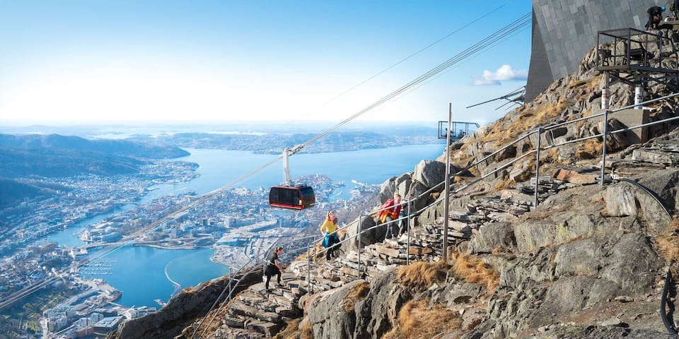
Hike up Mount Ulriken!
Distance: 3 km to City Centre
About
Ulriken is the highest of Bergen's seven mountains. A popular trip for both locals and visitors.
Hiking up Mount Ulriken is one of the most popular tours in Bergen. There are several different routes to the top of Ulriken, here is a couple of the most popular:
The most popular route: Start at Montana and walk the Sherpa steps (1333 stept):
Take bus No. 12 from the city center to Montana. Follow the signs to Montana Hostel. Turn right just before the hostel. Follow the gravel road uphill for approximately 15 mintues (0,8 kilometers). At the end of a gravel road you can select multiple paths up to Ulriken. Here you'll see a bench and signboard with a map and a river on your right. Follow the path straight onwards and it will make a sharp left bend. A few minutes later you'll see the steps. From here you follow the steps all the way to the top.
Start from Ulriken Cable car:
Take the bus to Haukeland hospital from outside Exhibition shopping center in the city center. Walk across the footbridge and follow the signs to Ulriksbanen. Just behind the cable car is the start point for the track up to the top. It starts with some stairs and continueson a gravel road for a short while. Turn right when you reach the first plateau before the red house. Cross over a small bridge, and you will come to the former parking lot at Montana. (Then follow the route above). Starting at the cable car will add about 20 minutes to your hike depending on how fast you walk.
"Eggen": If you do not like to climb stairs, you can take the path starting behind the signpost and the bench called Eggen. (So follow the road from Montana in the beginning.) The distance to the top is pretty much the same, and the view is very nice. However, on this path you will get a very steep climbing section. If you suffer from vertigo we recommend you walk the Sherpa steps. This route is not recommended for children. The trail is not well marked.
Duration:
The walk to Ulriken is suitable for all ages and takes about 1.5 hours from Montana. However, you will probably see a lot of very fit Norwegians running past using the steps as exercise rather than leisure.
Calculate a bit more time if you are walking with children. The walk offers great views all the way. This is a very popular trip for both locals and visitors. It is steep, but you are rewarded with stunning views along the way and of course panoramic views of Bergen and the surroundings from the top.
Season:
The walk is popular any time of year. However, in winter the steps are slippery from snow and ice and you need spikes on your shoes.
From the top of Ulriken you can take Ulriken Cable Car back if you do not want to walk down. Or you can continue accross Vidden to Mount Fløyen (approximately 5 hours). On top of Ulriken you can also treat yourself to a great meal at Skyskraperen Restaurant.
387 當地人推薦
Ulriken
Hike up Mount Ulriken!
Distance: 3 km to City Centre
About
Ulriken is the highest of Bergen's seven mountains. A popular trip for both locals and visitors.
Hiking up Mount Ulriken is one of the most popular tours in Bergen. There are several different routes to the top of Ulriken, here is a couple of the most popular:
The most popular route: Start at Montana and walk the Sherpa steps (1333 stept):
Take bus No. 12 from the city center to Montana. Follow the signs to Montana Hostel. Turn right just before the hostel. Follow the gravel road uphill for approximately 15 mintues (0,8 kilometers). At the end of a gravel road you can select multiple paths up to Ulriken. Here you'll see a bench and signboard with a map and a river on your right. Follow the path straight onwards and it will make a sharp left bend. A few minutes later you'll see the steps. From here you follow the steps all the way to the top.
Start from Ulriken Cable car:
Take the bus to Haukeland hospital from outside Exhibition shopping center in the city center. Walk across the footbridge and follow the signs to Ulriksbanen. Just behind the cable car is the start point for the track up to the top. It starts with some stairs and continueson a gravel road for a short while. Turn right when you reach the first plateau before the red house. Cross over a small bridge, and you will come to the former parking lot at Montana. (Then follow the route above). Starting at the cable car will add about 20 minutes to your hike depending on how fast you walk.
"Eggen": If you do not like to climb stairs, you can take the path starting behind the signpost and the bench called Eggen. (So follow the road from Montana in the beginning.) The distance to the top is pretty much the same, and the view is very nice. However, on this path you will get a very steep climbing section. If you suffer from vertigo we recommend you walk the Sherpa steps. This route is not recommended for children. The trail is not well marked.
Duration:
The walk to Ulriken is suitable for all ages and takes about 1.5 hours from Montana. However, you will probably see a lot of very fit Norwegians running past using the steps as exercise rather than leisure.
Calculate a bit more time if you are walking with children. The walk offers great views all the way. This is a very popular trip for both locals and visitors. It is steep, but you are rewarded with stunning views along the way and of course panoramic views of Bergen and the surroundings from the top.
Season:
The walk is popular any time of year. However, in winter the steps are slippery from snow and ice and you need spikes on your shoes.
From the top of Ulriken you can take Ulriken Cable Car back if you do not want to walk down. Or you can continue accross Vidden to Mount Fløyen (approximately 5 hours). On top of Ulriken you can also treat yourself to a great meal at Skyskraperen Restaurant.
About
Enjoy the spectacular panoramic view from the top of Løvstakken. Only 10 minutes by bus from the city center to the start of the hike.
Mount Løvstakken is 477 meters above sea level and is the highest mountain west of the city center. The highest of the seven mountains is Ulriken with 643 m.a.s.l
There are several hiking trails to the top of Løvstakken, the most common one starts at Løvstakkveien 51, close to Danmarksplass.
Public transport:
The best way to get to the beginning of the hike is to take the bus from the city center. From Lars Hilles gate (just behind KODE Art Museum) you can take bus number 10 to the stop called Blekenberg. The bus takes about 10 minutes.
Next to the bus stop is the supermarket Matkroken. Behind Matkroken you will see the first sign showing you the way towards the mountain.
If you take the Bybanen (Bergen Light Rail) from the city center or the airport, the closest stop is called Danmarksplass and it will take you approximately 15 minutes to walk to the start point.
Parking:
There is limited parking close to the starting point and we recommend that you park in the area around Danmarksplass or at the indoor parking at SolheimsGarasjen. From the garage it takes you 15 minutes to walk to the start point.
Tour start:
From the sign behind the shop, follow the shortcut by the steps. Take a left when you get to Løvstakkveien. At the t-junction take a right and continue straight ahead. The start is at the end of the road. You will see a signpost with a map showing the different routes to the top.
To the top:
From the starting point you will see the gravel road going alongside the mountain. Cross this road and follow the hiking trail straight ahead. After a while you will pass a big rock that says “Jesus lever”. Then you know that you are on the right track.
As you pass the tree line, the trail is mostly on mountain rocks, before you get to the top. At the top you get a panoramic view of Bergen city center, the seven mountains surrounding the city and all the way towards the airport and beyond.
Please note that when heading back down, the track is more challenging to follow. Mostly because there are several trails going in all directions and it is easy to suddenly follow the wrong one. However, this is one of the most popular hikes in Bergen and you will definitely meet friendly locals along the route that can guide you on to the right track.
Duration:
The hike to Løvstakken is 2,2 kilometers and takes approximately one hour up and a bit shorter coming down. The hike can be done all year, but is best between May and October. During the winter it can get slippery as a large part of the hike is on mountain rock only.
Bonus tip:
It is normally a bit windy on top, so bring a hoodie or a scarf, even if the weather is nice when you start. Then you can relax in comfort while enjoying the breathtaking view.
139 當地人推薦
Løvstakken
About
Enjoy the spectacular panoramic view from the top of Løvstakken. Only 10 minutes by bus from the city center to the start of the hike.
Mount Løvstakken is 477 meters above sea level and is the highest mountain west of the city center. The highest of the seven mountains is Ulriken with 643 m.a.s.l
There are several hiking trails to the top of Løvstakken, the most common one starts at Løvstakkveien 51, close to Danmarksplass.
Public transport:
The best way to get to the beginning of the hike is to take the bus from the city center. From Lars Hilles gate (just behind KODE Art Museum) you can take bus number 10 to the stop called Blekenberg. The bus takes about 10 minutes.
Next to the bus stop is the supermarket Matkroken. Behind Matkroken you will see the first sign showing you the way towards the mountain.
If you take the Bybanen (Bergen Light Rail) from the city center or the airport, the closest stop is called Danmarksplass and it will take you approximately 15 minutes to walk to the start point.
Parking:
There is limited parking close to the starting point and we recommend that you park in the area around Danmarksplass or at the indoor parking at SolheimsGarasjen. From the garage it takes you 15 minutes to walk to the start point.
Tour start:
From the sign behind the shop, follow the shortcut by the steps. Take a left when you get to Løvstakkveien. At the t-junction take a right and continue straight ahead. The start is at the end of the road. You will see a signpost with a map showing the different routes to the top.
To the top:
From the starting point you will see the gravel road going alongside the mountain. Cross this road and follow the hiking trail straight ahead. After a while you will pass a big rock that says “Jesus lever”. Then you know that you are on the right track.
As you pass the tree line, the trail is mostly on mountain rocks, before you get to the top. At the top you get a panoramic view of Bergen city center, the seven mountains surrounding the city and all the way towards the airport and beyond.
Please note that when heading back down, the track is more challenging to follow. Mostly because there are several trails going in all directions and it is easy to suddenly follow the wrong one. However, this is one of the most popular hikes in Bergen and you will definitely meet friendly locals along the route that can guide you on to the right track.
Duration:
The hike to Løvstakken is 2,2 kilometers and takes approximately one hour up and a bit shorter coming down. The hike can be done all year, but is best between May and October. During the winter it can get slippery as a large part of the hike is on mountain rock only.
Bonus tip:
It is normally a bit windy on top, so bring a hoodie or a scarf, even if the weather is nice when you start. Then you can relax in comfort while enjoying the breathtaking view.
About
Experience the panoramic view of the fjord and mountains from Hananipa. The hike is around 6 km back and forth from Nordre Skulstad, and suitable for most people.
The hike takes between 2 and 3 hours from the time you park at Nordre Skulstad, until you return to your cark. If you park in Trengereid, you must expect to use at least 30 minutes extra hour each way.
Trengereid is located 40 minutes drive from Bergen city centre. If you go by train, it takes just under 20 minutes from Bergen (you can take all trains going to Oslo, Voss or Myrdal).
Parking:
The hike starts at Nordre Skulstad, close to Skulstadvatnet (lake Skulstad). There is a small parking lot there, but if the parking lot is full you have to park down in Trengereid (we recommend parking at Trengereid train station)
From Trengereid you walk to the start of Skulstadvegen and follow it all the way to the top to Nordre Skulstad. It is about 3.5 km from Trengereid up to Nordre Skulstad, and the walk takes a little over half an hour. If you go on this hike on a Saturday or Sunday, it is possible to park at Trengereid school, at the very beginning of Skulstadvegen.
About the hike:
From Nordre Skulstad you can follow a construction road up to the lake. This is where the hike starts up to Hananipa, the top of which is 718 meters above sea level. The hiking trail is easy to spot and easy to follow. The hike to the top is around 3 kilometers, in relatively easy terrain. The climb is almost 350 meters, so make sure you do not set off to fast. The terrain can be a bit reminiscent of Hobbit land if you are familiar with The Lord of the Rings, and along the way there is as much a chance of meeting sheep as other hikers.
From the top of Hananipa you can enjoy a 360 degree panoramic view of Vaksdal and Osterøy, the dark blue Sørfjord far down below and the mountain tops Gullfjelltoppen, Tveitakvitingen and Fuglafjellet. When you get tired of the view (if that is possible…) you can take the same trail back down. The hike itself will then be around 6 kilometers and takes between 2 and 3 hours back and forth, if you were able to park at Nordre Skulstad.
Hananipa
About
Experience the panoramic view of the fjord and mountains from Hananipa. The hike is around 6 km back and forth from Nordre Skulstad, and suitable for most people.
The hike takes between 2 and 3 hours from the time you park at Nordre Skulstad, until you return to your cark. If you park in Trengereid, you must expect to use at least 30 minutes extra hour each way.
Trengereid is located 40 minutes drive from Bergen city centre. If you go by train, it takes just under 20 minutes from Bergen (you can take all trains going to Oslo, Voss or Myrdal).
Parking:
The hike starts at Nordre Skulstad, close to Skulstadvatnet (lake Skulstad). There is a small parking lot there, but if the parking lot is full you have to park down in Trengereid (we recommend parking at Trengereid train station)
From Trengereid you walk to the start of Skulstadvegen and follow it all the way to the top to Nordre Skulstad. It is about 3.5 km from Trengereid up to Nordre Skulstad, and the walk takes a little over half an hour. If you go on this hike on a Saturday or Sunday, it is possible to park at Trengereid school, at the very beginning of Skulstadvegen.
About the hike:
From Nordre Skulstad you can follow a construction road up to the lake. This is where the hike starts up to Hananipa, the top of which is 718 meters above sea level. The hiking trail is easy to spot and easy to follow. The hike to the top is around 3 kilometers, in relatively easy terrain. The climb is almost 350 meters, so make sure you do not set off to fast. The terrain can be a bit reminiscent of Hobbit land if you are familiar with The Lord of the Rings, and along the way there is as much a chance of meeting sheep as other hikers.
From the top of Hananipa you can enjoy a 360 degree panoramic view of Vaksdal and Osterøy, the dark blue Sørfjord far down below and the mountain tops Gullfjelltoppen, Tveitakvitingen and Fuglafjellet. When you get tired of the view (if that is possible…) you can take the same trail back down. The hike itself will then be around 6 kilometers and takes between 2 and 3 hours back and forth, if you were able to park at Nordre Skulstad.
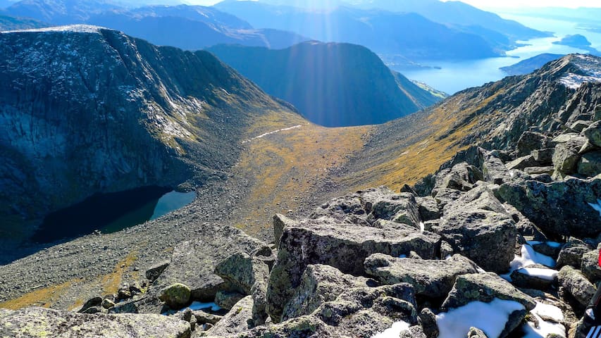
Trolltunga is no doubt one of the most awe-inspiring cliffs in Norway, situated about 1,100 meters above sea level and hovering some 700 metres above Lake Ringedalsvatnet.
At the western edge of the Hardangervidda mountain plateau and near the town of Odda, Trolltunga (the troll’s tongue) and the valley below were carved out by an icecap that covered most of Scandinavia during a series of ice ages. Every year, travellers from all over the world come here to do the hike and get a picture of themselves on or in front of the world-famous cliff.
Season
The hiking season lasts from 1 June to 31 August. Guided hiking is recommended, but experienced hikers can go on their own. Start your hike before 8 am to make sure you’ll get back before it gets dark.
10–12-hour hike
The hike through high-mountain terrain up to Trolltunga (1,180 metres above sea level) is long and demanding both physically and mentally. You need to be properly equipped and in good shape, if you want to embark on this hike. But if you do, you will be rewarded with magnificent views!
From the main trailhead in Skjeggedal, the round-trip hike is 27 kilometres with an ascent of almost 800 metres, so you have to be prepared for a hike of 10–12 hours including breaks.
From the trailhead at Mågelitopp, the hike there and back again is 20 kilometres with an ascent of about 320 metres. Estimated hiking time is 7–10 hours.
Signs along the trail show the remaining distance to both Trolltunga and back to the trailhead.
We recommend that you have at least two days at your disposal to increase the chances of nice weather. Trolltunga is surrounded by steep cliffs and there are no fences. Falling from a cliff because of fog can certainly be fatal, so be aware.
141 當地人推薦
Trolltunga
Trolltunga is no doubt one of the most awe-inspiring cliffs in Norway, situated about 1,100 meters above sea level and hovering some 700 metres above Lake Ringedalsvatnet.
At the western edge of the Hardangervidda mountain plateau and near the town of Odda, Trolltunga (the troll’s tongue) and the valley below were carved out by an icecap that covered most of Scandinavia during a series of ice ages. Every year, travellers from all over the world come here to do the hike and get a picture of themselves on or in front of the world-famous cliff.
Season
The hiking season lasts from 1 June to 31 August. Guided hiking is recommended, but experienced hikers can go on their own. Start your hike before 8 am to make sure you’ll get back before it gets dark.
10–12-hour hike
The hike through high-mountain terrain up to Trolltunga (1,180 metres above sea level) is long and demanding both physically and mentally. You need to be properly equipped and in good shape, if you want to embark on this hike. But if you do, you will be rewarded with magnificent views!
From the main trailhead in Skjeggedal, the round-trip hike is 27 kilometres with an ascent of almost 800 metres, so you have to be prepared for a hike of 10–12 hours including breaks.
From the trailhead at Mågelitopp, the hike there and back again is 20 kilometres with an ascent of about 320 metres. Estimated hiking time is 7–10 hours.
Signs along the trail show the remaining distance to both Trolltunga and back to the trailhead.
We recommend that you have at least two days at your disposal to increase the chances of nice weather. Trolltunga is surrounded by steep cliffs and there are no fences. Falling from a cliff because of fog can certainly be fatal, so be aware.
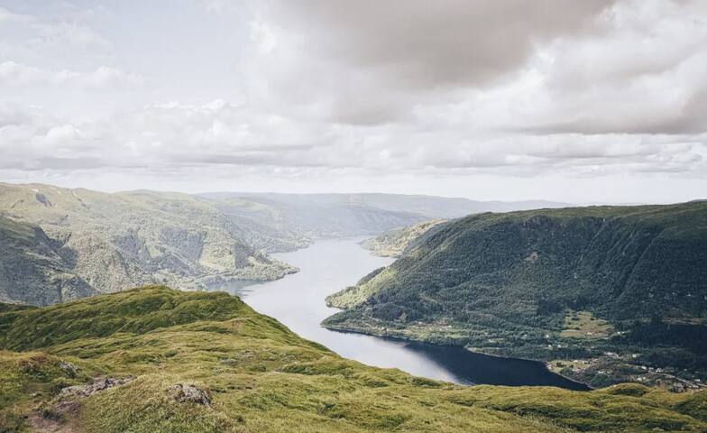
Hike, where you at the top of Melderskin can enjoy a magnificent view towards the ocean, fjords and mountains, and the Folgefonna Glacier.
LocationRosendal.MapMap of Folgefonna National ParkRosendal Turgruppe's route map.Start and stop pointKlettaParkingDrive towards the Baroniet, but turn left to Kletta at the intersection before the tree-lined avenue up to the Baroniet.There is a parking lot by the stop sign at Kletta. MarkingInformation Board by the parking lot. From here, 300 meters along the road is without marking before the path turns up towards Skardshaug. T markings, signs and cairns.GradingBlackChallenging hike, four boots according to the DNT system.Difference in altitude160 - 1426m AMSLTime used4 hours up, slightly less downRecommended adviceBring plenty to drink.Tour descriptionFrom the parking lot, 300 meters along the road is without marking before the path turns up towards Skardshaug.The path goes first through outlying fields and mixed forest. Above the tree-line, the path follows small ridges and valleys called Rindane. The first top, Skardshaug, is halfway to Melderskin. The view here is excellent. The valley towards the southeast is the Hattebergsdalen Valley, an important entrance to the Hatteberg Water Way and Folgefonna National Park. The surface then turns into more rocks and less vegetation. The "moss carpet" and the fresh spring water in Holo are unexpected surprises. Here you may find snow all summer long. The cairn on the flat top plateau was built by the Norwegian Geographical Survey Department in 1913. There is a magnificent view towards the ocean, fjords and mountains, and the Folgefonna Glacier. Melderskin is often called "The Queen Among The Hordaland Mountains".
7 當地人推薦
Melderskin
Hike, where you at the top of Melderskin can enjoy a magnificent view towards the ocean, fjords and mountains, and the Folgefonna Glacier.
LocationRosendal.MapMap of Folgefonna National ParkRosendal Turgruppe's route map.Start and stop pointKlettaParkingDrive towards the Baroniet, but turn left to Kletta at the intersection before the tree-lined avenue up to the Baroniet.There is a parking lot by the stop sign at Kletta. MarkingInformation Board by the parking lot. From here, 300 meters along the road is without marking before the path turns up towards Skardshaug. T markings, signs and cairns.GradingBlackChallenging hike, four boots according to the DNT system.Difference in altitude160 - 1426m AMSLTime used4 hours up, slightly less downRecommended adviceBring plenty to drink.Tour descriptionFrom the parking lot, 300 meters along the road is without marking before the path turns up towards Skardshaug.The path goes first through outlying fields and mixed forest. Above the tree-line, the path follows small ridges and valleys called Rindane. The first top, Skardshaug, is halfway to Melderskin. The view here is excellent. The valley towards the southeast is the Hattebergsdalen Valley, an important entrance to the Hatteberg Water Way and Folgefonna National Park. The surface then turns into more rocks and less vegetation. The "moss carpet" and the fresh spring water in Holo are unexpected surprises. Here you may find snow all summer long. The cairn on the flat top plateau was built by the Norwegian Geographical Survey Department in 1913. There is a magnificent view towards the ocean, fjords and mountains, and the Folgefonna Glacier. Melderskin is often called "The Queen Among The Hordaland Mountains".
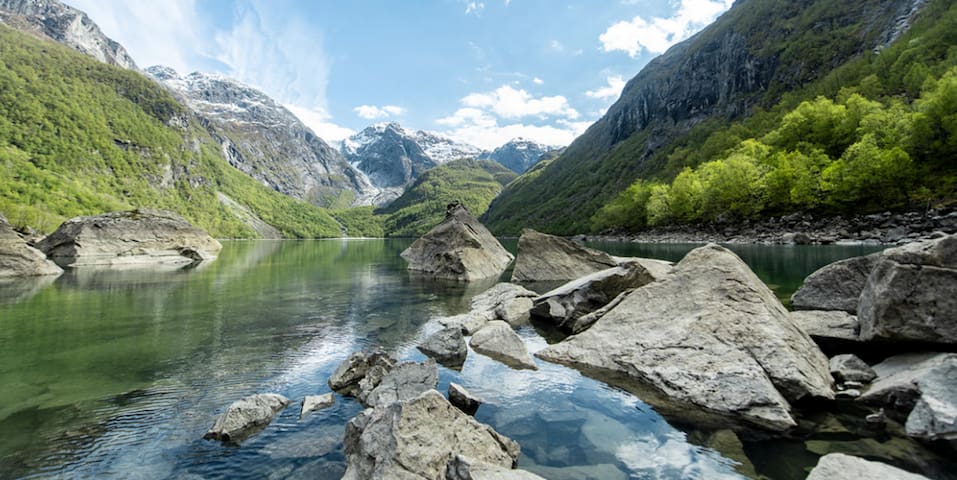
Lake Bondhusvatnet
Bondhusvatnet glacier lake near Sundal in Kvinnherad is a popular destination and one of the most popular hikes in the Hardanger region. The hike is short and not demanding and you can do it all year round.
Bondhusbrea and Bondhusvatnet have been a popular destination since the mid-1800s, and it has not become less popular over the years. Pictures of the photo-friendly glacier water appear more and more frequently on social media, and it is not without reason. The colors of the lake, the unique landscape, and the glacier in the background make Bondhusdalen one of the most beautiful valleys in Norway.
The hike up from the parking lot in Sundal is not demanding at all. Both strollers and wheelchairs, though with a powerful engine, can get up the valley to Bondhusvatnet. Walking in «normal» speed, it is a 2 hour long round trip. If you want to go all the way to the glacier, it takes an additional hour.
13 當地人推薦
Bondhusvatnet
Lake Bondhusvatnet
Bondhusvatnet glacier lake near Sundal in Kvinnherad is a popular destination and one of the most popular hikes in the Hardanger region. The hike is short and not demanding and you can do it all year round.
Bondhusbrea and Bondhusvatnet have been a popular destination since the mid-1800s, and it has not become less popular over the years. Pictures of the photo-friendly glacier water appear more and more frequently on social media, and it is not without reason. The colors of the lake, the unique landscape, and the glacier in the background make Bondhusdalen one of the most beautiful valleys in Norway.
The hike up from the parking lot in Sundal is not demanding at all. Both strollers and wheelchairs, though with a powerful engine, can get up the valley to Bondhusvatnet. Walking in «normal» speed, it is a 2 hour long round trip. If you want to go all the way to the glacier, it takes an additional hour.
The Barony in Rosendal the only one of its kind in Norway and a major attraction in Western Norway.
The Barony in Rosendal the only one of its kind in Norway and a major attraction in Western Norway. Among other things, the manor house is famous for its magnificent Renaissance garden and its rich calendar of cultural events, including concerts, courtyard theatre and art exhibitions. The pleasant garden cafe is situated beside the herb garden.
Things to see: Concerts in The Great Hall. Theatre in the Courtyard. A 300 year old renaissance garden with roses in abundance. Romantic landscaped garden from 1850 with viewpoints overlooking the fjord, mountains and waterfalls. The tennant's farm Treo gives an impression of everyday life with farm animals and activities. Kitchen & Herbgarden with herbs, flowers, vegetables & fruits. The Chef at Baroniet Rosendal serves dinners with ingredients from the garden at the Herbgarden café(along with concerts) B&B at Baroniet Rosendal Avlsgård & Fruehus from 1850.
Please see the web page of Baroniet Rosendal for more information due to guided tours and more.
Free entrance to Rosendal Gardens outside the opening hours and off season!
50 當地人推薦
羅森達爵位領地
60 BaronivegenThe Barony in Rosendal the only one of its kind in Norway and a major attraction in Western Norway.
The Barony in Rosendal the only one of its kind in Norway and a major attraction in Western Norway. Among other things, the manor house is famous for its magnificent Renaissance garden and its rich calendar of cultural events, including concerts, courtyard theatre and art exhibitions. The pleasant garden cafe is situated beside the herb garden.
Things to see: Concerts in The Great Hall. Theatre in the Courtyard. A 300 year old renaissance garden with roses in abundance. Romantic landscaped garden from 1850 with viewpoints overlooking the fjord, mountains and waterfalls. The tennant's farm Treo gives an impression of everyday life with farm animals and activities. Kitchen & Herbgarden with herbs, flowers, vegetables & fruits. The Chef at Baroniet Rosendal serves dinners with ingredients from the garden at the Herbgarden café(along with concerts) B&B at Baroniet Rosendal Avlsgård & Fruehus from 1850.
Please see the web page of Baroniet Rosendal for more information due to guided tours and more.
Free entrance to Rosendal Gardens outside the opening hours and off season!
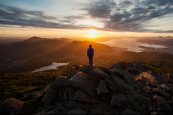
A walk suitable for all ages! Enjoy the beautiful views and windy roads from Mount Fløyen down to the city center.
If steep climbs are not for you, you can take the Fløibanen funicular up to the top and walk down to central Bergen. This is a popular walk suitable for people of all ages, and it takes around 1 hour (or less if you are a fast walker). Needless to say, you can walk up to Fløyen too - it just takes a bit longer.
If you have a stroller or buggy, or young children, it’s no problem - you’ll easily get a place for the buggy on the Fløibanen, and then walk down to Bergen city centre.
The Fløibanen funicular has several stops on its way up the mountainside. If you don't feel up to walking the whole way down, you can take the funicular halfway down to Fjellveien for example and take the last bit of the the journey by foot. This is especially useful in the winter when it can easily get icy up top.
On this walk you will have a golden opportunity to take great pictures of fantastic views and charming old wooden buildings.
The route winds its way down from the mountain with many twists and turns, but it is easy to find your way. On your way down, make sure you leave plenty of time to relax on one of the many benches along the way. They are placed so that you can really take in the great view.
When you are almost at the bottom, you will set eyes on the lovely Skansedammen. In winter it’s frequented by people going ice skating. In the summer, the beatiful lake is a popular picnic spot. Maybe you could round off your walk with a picnic too?
How to walk up to Fløyen:
There are several paths you can walk up to Fløyen from Bergen city centre. The walk takes between 45 minutes and 1 hour depending on your pace and how many stops you make along the way to enjoy the spectacular view.
The first part of the walk follows the same path. From the lower station of Fløibanen on Vetrlidsallmenningen, you walk up past Skansedammen and then to Fjellveien. If you want to get to the top as quickly as possible, Fløysvingene is the route for you. The route starts in Fjellveien by the drinking fountain, about 200 meters north of Fløybanestoppet. As you can deduct from the name, this road turns from Fjellveien and almost straight up the mountain.
Just above Fjellveien you can take a detour from Fløysvingene and continue on the northern route up Fløyen, called Tippetue. This route offers a glorious view of Ytre Sandviken and Byfjorden. This route meets Fløysvingene again at Pilen, about 5 minutes walk from Fløybanen's upper station. Most of Fløysvingene and Tippetue is gravel road.
From Fjellveien you can also choose the road towards the sports facility Skansemyren. On the left side of the sports facility, the road continues upwards. The road is paved and along the way there is a great view of Ulriken and Bergen south. There will be some construction traffic on this road during the upgrading.
If you like walking in the mountains, we also recommend these hikes around Bergen’s seven mountains.
531 當地人推薦
Fløyen
A walk suitable for all ages! Enjoy the beautiful views and windy roads from Mount Fløyen down to the city center.
If steep climbs are not for you, you can take the Fløibanen funicular up to the top and walk down to central Bergen. This is a popular walk suitable for people of all ages, and it takes around 1 hour (or less if you are a fast walker). Needless to say, you can walk up to Fløyen too - it just takes a bit longer.
If you have a stroller or buggy, or young children, it’s no problem - you’ll easily get a place for the buggy on the Fløibanen, and then walk down to Bergen city centre.
The Fløibanen funicular has several stops on its way up the mountainside. If you don't feel up to walking the whole way down, you can take the funicular halfway down to Fjellveien for example and take the last bit of the the journey by foot. This is especially useful in the winter when it can easily get icy up top.
On this walk you will have a golden opportunity to take great pictures of fantastic views and charming old wooden buildings.
The route winds its way down from the mountain with many twists and turns, but it is easy to find your way. On your way down, make sure you leave plenty of time to relax on one of the many benches along the way. They are placed so that you can really take in the great view.
When you are almost at the bottom, you will set eyes on the lovely Skansedammen. In winter it’s frequented by people going ice skating. In the summer, the beatiful lake is a popular picnic spot. Maybe you could round off your walk with a picnic too?
How to walk up to Fløyen:
There are several paths you can walk up to Fløyen from Bergen city centre. The walk takes between 45 minutes and 1 hour depending on your pace and how many stops you make along the way to enjoy the spectacular view.
The first part of the walk follows the same path. From the lower station of Fløibanen on Vetrlidsallmenningen, you walk up past Skansedammen and then to Fjellveien. If you want to get to the top as quickly as possible, Fløysvingene is the route for you. The route starts in Fjellveien by the drinking fountain, about 200 meters north of Fløybanestoppet. As you can deduct from the name, this road turns from Fjellveien and almost straight up the mountain.
Just above Fjellveien you can take a detour from Fløysvingene and continue on the northern route up Fløyen, called Tippetue. This route offers a glorious view of Ytre Sandviken and Byfjorden. This route meets Fløysvingene again at Pilen, about 5 minutes walk from Fløybanen's upper station. Most of Fløysvingene and Tippetue is gravel road.
From Fjellveien you can also choose the road towards the sports facility Skansemyren. On the left side of the sports facility, the road continues upwards. The road is paved and along the way there is a great view of Ulriken and Bergen south. There will be some construction traffic on this road during the upgrading.
If you like walking in the mountains, we also recommend these hikes around Bergen’s seven mountains.
About
The tour between Mount Ulriken and Mount Fløyen is one of the the most popular tours in Bergen. Beautiful views of Bergen and the region.
You can start and end your trip by taking Ulriken Cable Car or Fløibanen funicular. Between these two beautiful mountains you can see the fjords and islands around Bergen. On a clear day you can enjoy the view to Folgefonna glacier.
If you want to walk up Mount Ulriken, you can take bus nr 12 to Montana. Follow the signs to Montana Youth Hostel. Turn right just before the hostel and across the parking place you will see the gravel road which is the start point. Follow the road for about 10 minutes. At the end you will have several options up to Ulriken. The quickest (and steepest) is to follow the signs "Ulriken opp". This is the most popular track. If you want a longer and more gentle climb, keep right after about 10 minutes after the gravel road is finished. (Towards Nattlandsfjellet og Sedalen).
Alternatively you can take any buss which goes to the hospital. From the hospital it is a 10 minute walk up to Ulriken Cable car. From there you can take the Cable car to the top or walk “underneath” it. The track starts just to the right of the entrance and will meet up with the track from Montana after about 20 minutes. (You will see the parking lot on your right, across the little bridge.)
The hike across Vidden is well marked and is very popular amongst locals. The last 1-1,5 hours is on gravel road coming up to Mount Rundeman. From there you will start seeing the view of the city.
15 minutes before Mount Fløyen you can stop at Brushytten and enjoy a Norwegian waffle. Open every Sunday between 11-16 the whole year.
With a guide:
You can do this walk on your own or enjoy the company, safety and knowledge of a local guide from Norway Mountain Guides.
Season: The hike takes about 5 hours and can be done the whole year, but we recommend between May and October, unless you are skiing across! Make sure you check the weather conditions before starting the hike. Remember that from October the days are starting to get shorter with less daylight as we are heading towards winter.
Camping and swimming:
Camping is allowed for up to 2 days in the city mountains. Exceptions around Fløyen and in areas close to drinking waters or waters supplying, adjoining or close to the drinking waters. Swimming is permitted in any water that is not drinking water or within the catchment for drinking waters.
Height difference: 20-662 meters
Estimated time: 5 hours
Length: 15 km
Starting point: Mount Fløyen or Mount Ulriken
8 當地人推薦
Vidden Start
About
The tour between Mount Ulriken and Mount Fløyen is one of the the most popular tours in Bergen. Beautiful views of Bergen and the region.
You can start and end your trip by taking Ulriken Cable Car or Fløibanen funicular. Between these two beautiful mountains you can see the fjords and islands around Bergen. On a clear day you can enjoy the view to Folgefonna glacier.
If you want to walk up Mount Ulriken, you can take bus nr 12 to Montana. Follow the signs to Montana Youth Hostel. Turn right just before the hostel and across the parking place you will see the gravel road which is the start point. Follow the road for about 10 minutes. At the end you will have several options up to Ulriken. The quickest (and steepest) is to follow the signs "Ulriken opp". This is the most popular track. If you want a longer and more gentle climb, keep right after about 10 minutes after the gravel road is finished. (Towards Nattlandsfjellet og Sedalen).
Alternatively you can take any buss which goes to the hospital. From the hospital it is a 10 minute walk up to Ulriken Cable car. From there you can take the Cable car to the top or walk “underneath” it. The track starts just to the right of the entrance and will meet up with the track from Montana after about 20 minutes. (You will see the parking lot on your right, across the little bridge.)
The hike across Vidden is well marked and is very popular amongst locals. The last 1-1,5 hours is on gravel road coming up to Mount Rundeman. From there you will start seeing the view of the city.
15 minutes before Mount Fløyen you can stop at Brushytten and enjoy a Norwegian waffle. Open every Sunday between 11-16 the whole year.
With a guide:
You can do this walk on your own or enjoy the company, safety and knowledge of a local guide from Norway Mountain Guides.
Season: The hike takes about 5 hours and can be done the whole year, but we recommend between May and October, unless you are skiing across! Make sure you check the weather conditions before starting the hike. Remember that from October the days are starting to get shorter with less daylight as we are heading towards winter.
Camping and swimming:
Camping is allowed for up to 2 days in the city mountains. Exceptions around Fløyen and in areas close to drinking waters or waters supplying, adjoining or close to the drinking waters. Swimming is permitted in any water that is not drinking water or within the catchment for drinking waters.
Height difference: 20-662 meters
Estimated time: 5 hours
Length: 15 km
Starting point: Mount Fløyen or Mount Ulriken
城市觀光建議
不容錯過
Hiking in and around Bergen
If you love nature…