
Mi Tall Story guidebook
Sightseeing & Experiences
黑斯廷斯洞穴和溫泉
754 Hastings Caves RdDon't forget your bathers!! Takes some food for a BBQ at the Thermal Pools
The walk to Duckhole Lake, south of Dover, takes around 1.5 hours (4.2 km return) and is so delightful it’s made the list of Tasmania’s 60 Great Short Walks. The track winds through a forest of stringybarks, sassafras, myrtle, and sections of tea tree swamp, following a late 19th century sawmill tramway for much of the way. The lake itself is the epitome of tranquility (although it’s actually a flooded sinkhole).
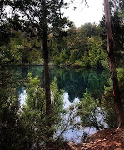
Duckhole Lake Track
Duckhole Lake TrackThe walk to Duckhole Lake, south of Dover, takes around 1.5 hours (4.2 km return) and is so delightful it’s made the list of Tasmania’s 60 Great Short Walks. The track winds through a forest of stringybarks, sassafras, myrtle, and sections of tea tree swamp, following a late 19th century sawmill tramway for much of the way. The lake itself is the epitome of tranquility (although it’s actually a flooded sinkhole).
Cockle Creek is the paradise at the end of Australia’s southern-most road. Forested hills roll right down to the water and distant peaks enhance the stunning scenery. Walk along the white sandy beach and paddle in the crystal-clear water. Find the whale sculpture and walk to the Fishers Point Navigation Light and Pilot Station ruins (2 hrs return). Wander the historic cemetery and ponder the lives of early settlers.
27 當地人推薦
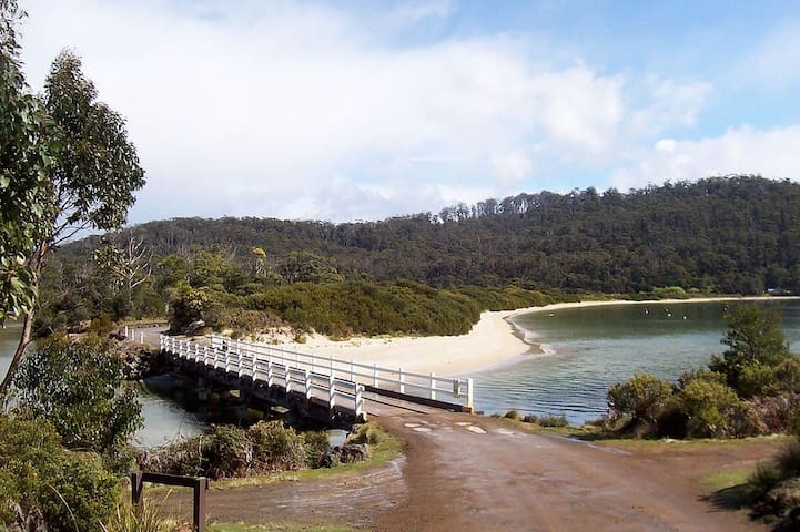
Cockle Creek
Cockle Creek is the paradise at the end of Australia’s southern-most road. Forested hills roll right down to the water and distant peaks enhance the stunning scenery. Walk along the white sandy beach and paddle in the crystal-clear water. Find the whale sculpture and walk to the Fishers Point Navigation Light and Pilot Station ruins (2 hrs return). Wander the historic cemetery and ponder the lives of early settlers.
The park makes up part of Tasmania’s Wilderness World Heritage Area and features some of the country’s most untouched coastline, button grass plains, wild rivers, dramatic mountain ranges, and ancient rainforest. The South Cape Bay Track (4 hrs return / 7.7 km one way) offers a taste of the famed multi-day South Coast Track. Keep an eye out for the local wildlife, including special birdlife.
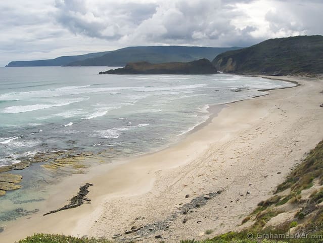
Southwest National Park
The park makes up part of Tasmania’s Wilderness World Heritage Area and features some of the country’s most untouched coastline, button grass plains, wild rivers, dramatic mountain ranges, and ancient rainforest. The South Cape Bay Track (4 hrs return / 7.7 km one way) offers a taste of the famed multi-day South Coast Track. Keep an eye out for the local wildlife, including special birdlife.
This is a tough 7Hr walk on steep ground!!
The track climbs slightly as it follows the remains of one of the tramways used for removing trees previously and then climbs steeply to Manuka Flat. This takes 30-40 minutes. Some trees are down across the track and have to be clambered over. There are a couple of very steep sections and mud makes it a bit slippery in wet conditions. From Manuka Flat the track firstly sidles left slightly and climbs gently around the slope of the hill, then climbs steeply and directly up the hill. There is now a long solid climb to the plateau.
At the top, the track suddenly turns right along the hill, and a small trickle of water provides a welcome drink at a point with a good view back across the walk route. The track then switches back to the left and climbs onto the plateau to the "hut". The hut is in an advanced state of disrepair, and the only useful features here are the huge wall which provides some shelter from the wind, and the remains of the chimney, which helps support a sheet of tin that might provide shelter from the rain.
The track then heads off across the moor, past a cairn, and becomes muddy in places. From here the aim is the northern moraine wall above the boggy area which forms the source of Creekton Rivulet. The track climbs steadily to the base of this moraine across some boggy areas, then up onto it and follows the crest onto the main summit ridge. It climbs steeply up the ridge, sidling around the left a little before crossing back to the right just below a rocky knob. The track drops slightly, then climbs again on large boulders marked with cairns. Finally you emerge at a rounded summit, marked by a large cairn made of ice-shattered dolerite shards.
Adamsons Peak Walk
Peak Rivulet RoadThis is a tough 7Hr walk on steep ground!!
The track climbs slightly as it follows the remains of one of the tramways used for removing trees previously and then climbs steeply to Manuka Flat. This takes 30-40 minutes. Some trees are down across the track and have to be clambered over. There are a couple of very steep sections and mud makes it a bit slippery in wet conditions. From Manuka Flat the track firstly sidles left slightly and climbs gently around the slope of the hill, then climbs steeply and directly up the hill. There is now a long solid climb to the plateau.
At the top, the track suddenly turns right along the hill, and a small trickle of water provides a welcome drink at a point with a good view back across the walk route. The track then switches back to the left and climbs onto the plateau to the "hut". The hut is in an advanced state of disrepair, and the only useful features here are the huge wall which provides some shelter from the wind, and the remains of the chimney, which helps support a sheet of tin that might provide shelter from the rain.
The track then heads off across the moor, past a cairn, and becomes muddy in places. From here the aim is the northern moraine wall above the boggy area which forms the source of Creekton Rivulet. The track climbs steadily to the base of this moraine across some boggy areas, then up onto it and follows the crest onto the main summit ridge. It climbs steeply up the ridge, sidling around the left a little before crossing back to the right just below a rocky knob. The track drops slightly, then climbs again on large boulders marked with cairns. Finally you emerge at a rounded summit, marked by a large cairn made of ice-shattered dolerite shards.
Dover
A great thing to do if you have time...
https://esperanceadventures.com.au/
Dover
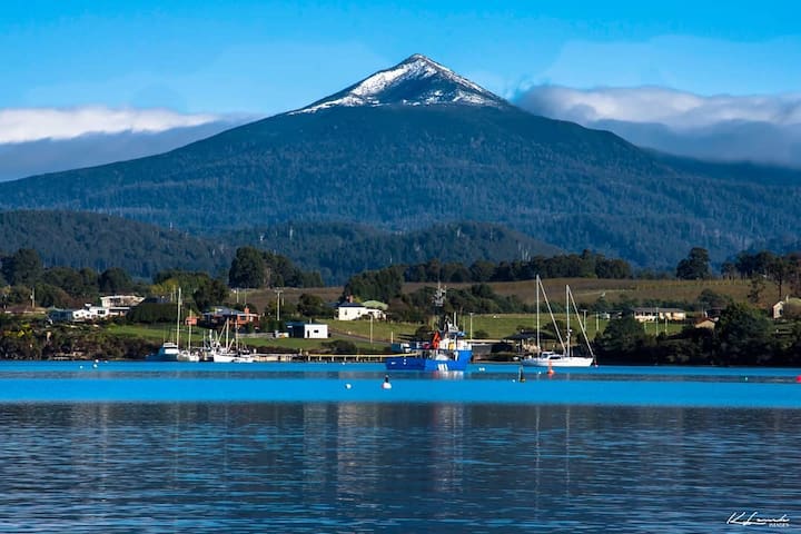
Dover is the southernmost town of its size in Australia, located on the western shores towards the southern end of the D'Entrecasteaux Channel, just south of the Huon Valley, southwest of Hobart, located on the head of Port Esperance in Tasmania.
12 當地人推薦
Dover
Dover is the southernmost town of its size in Australia, located on the western shores towards the southern end of the D'Entrecasteaux Channel, just south of the Huon Valley, southwest of Hobart, located on the head of Port Esperance in Tasmania.
City/town information
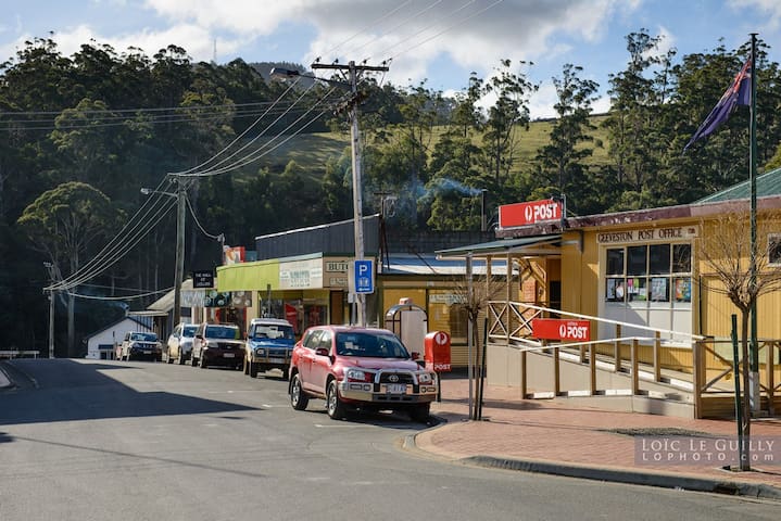
Geeveston is a small town in the south of Tasmania in Australia on the Huon River, 62 km south west of Hobart, making it Australia's most southerly administrative centre.
23 當地人推薦
Geeveston
Geeveston is a small town in the south of Tasmania in Australia on the Huon River, 62 km south west of Hobart, making it Australia's most southerly administrative centre.
Food scene
Southernmost Hotel in Tasmania. Family-friendly hotel, bistro dining, accommodation ranging from self-contained motel units, to powered and unpowered camping. A convenience store is on site, selling groceries, fuel, takeaway food and coffee. Located only 800m from the beach. WINTER TRADING HOURS: Open for meals from 12-2pm for lunch Wednesday - Sunday. Open for meals from 6-8pm for tea Monday - Sunday.
10 當地人推薦
Southport Hotel & Caravan Park
8777 Huon HwySouthernmost Hotel in Tasmania. Family-friendly hotel, bistro dining, accommodation ranging from self-contained motel units, to powered and unpowered camping. A convenience store is on site, selling groceries, fuel, takeaway food and coffee. Located only 800m from the beach. WINTER TRADING HOURS: Open for meals from 12-2pm for lunch Wednesday - Sunday. Open for meals from 6-8pm for tea Monday - Sunday.
Quirky Rocket pop-up cafe at the end of the Highway going south in Australia. Great coffee, home-made cookies, scoop icecream, local arts and produce and handy space facts.
Rocket@the End of the Road
8856 Huon HwyQuirky Rocket pop-up cafe at the end of the Highway going south in Australia. Great coffee, home-made cookies, scoop icecream, local arts and produce and handy space facts.
The wood fired pizza is absolutely amazing. So fresh and tasty. Great choice of wines and cider and you are made very welcome when you first walk in
11 當地人推薦
Post Office 6985
6985 Huon HwyThe wood fired pizza is absolutely amazing. So fresh and tasty. Great choice of wines and cider and you are made very welcome when you first walk in
Large, clean and well furnished Bistro area. Service was fast and friendly. Menu had something for all including a delicious vegetarian Lasagna and all meals were generous. Prices were very reasonable.
12 當地人推薦
Dover RSL Club
16 Chapman AveLarge, clean and well furnished Bistro area. Service was fast and friendly. Menu had something for all including a delicious vegetarian Lasagna and all meals were generous. Prices were very reasonable.
Bakehouse Distillery
8 Station RdRiver Run Lodge was founded by like minded entrepreneurs, people who share a passion for traveling and exploring. Service, design and simplicity are at our core; when you book a stay with us, you’re guaranteed to have an memorable experience
Far South Wilderness Lodge
247 Narrows RdRiver Run Lodge was founded by like minded entrepreneurs, people who share a passion for traveling and exploring. Service, design and simplicity are at our core; when you book a stay with us, you’re guaranteed to have an memorable experience